|
|
||
|
|
|
|
||
|
|

|
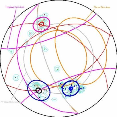
Rock Stability Recognition (Rock Sta. R.) is a statistical application on Rockmass Joints. Data collected with the geological compass on site field, can be plotted on the Equal Area Stereonet (Schmidt's net) in joint sets or individually. Then graphical results concerning the density (contours) and the standand deviation of the data, are infered.
It is also available the choice of Toppling, Planar Sliding and Wedge Sliding analysis,
which means that the risk area zones simultaneously with the plotted data can be seen on your screen for a given slope geometry. Additionally, many tools and options such as shapes, visibilty or not of the stereonet ect. are available for formating that give you the ability of personalization of your projects.
On the right field of this page you can download the demo version and the manual of the program which is identical to the full version except the number of measurements you can import.
Don't hesitate to contact with us in any relative problem you encouter. Please tell us your suggestions and share your ideas with us. Help us improve our softwares. |
 Demo of Rock Sta. R. v1.1 Manual of Rock Sta. R. v1.1 |